

Skip to content
AgroPipe

Field-to-Deal · from the farm to the signed deal

See where your market potential is, farm by farm.

Field-to-Deal for agribusiness: from the farm to the signed deal, in one flow. AgroPipe maps the territory of companies that sell to Brazilian farmers, estimates the buying potential of every rural property and runs your team's prospecting all the way to the close.

Ag retailers Fuel distributors Co-ops Grain elevators Machinery dealers Agribusiness industries

One platform:
Market map AI assistant Potential per farm Sales pipeline Customer portfolio Field app

The unit is the rural property

Every farm in your territory, with what matters to sell

Instead of lists and spreadsheets, AgroPipe starts from the map. Every farm comes with its area, cropland, crop history and a buying potential calculated for what your company sells.

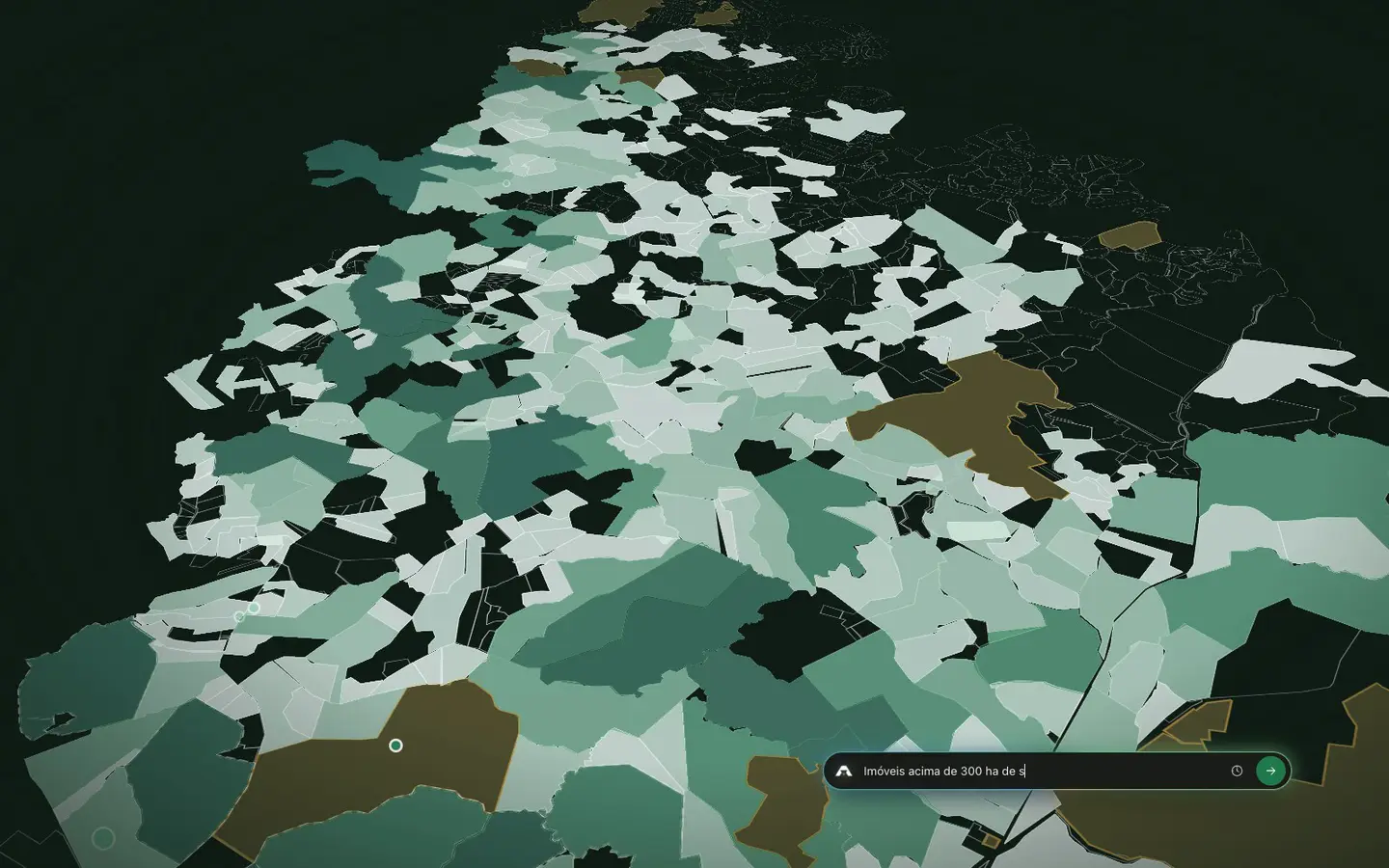
AgroPipe map: farms colored by buying potentialReal product mapYour whole territory, farm by farmEvery property with the attributes below, ready to filter, color and prioritize.
Boundaries and areaThe outline of each property, its total area in hectares and an identification code.
Cropland and land useHow much of the farm is cropland, pasture or native vegetation, and the trend over the years.
Crops by seasonSoybeans, corn, wheat and other crops mapped on each farm, season by season.
Buying potentialEstimated volume and revenue for each of your products, with the formula in plain sight.
Customer or notWho already buys from you, who buys from someone else and who nobody serves.
Nearby competitorsRetailers, co-ops and distributors on the map, and where nobody competes yet.
Silos and storageGrain storage near each farm, a signal of scale and grain origination.
Social and environmental riskRestriction flags that weigh on credit and sales decisions, in each farm's profile.

The problem

Selling to farmers “in the dark” is expensive

Most agribusiness sales teams work from a list of existing customers, a spreadsheet nobody updates and the rep's memory. The rest of the market stays invisible.

A spreadsheet does not show the market

It lists who already bought. It does not tell you how many farms there are in your territory, how much each one can buy or who has no supplier.

In AgroPipe, the whole territory is on the map, with the potential of every farm.

Reps head out without a route

They visit who they already know, drive past bigger opportunities and do not log what was agreed. The manager only finds out at the end of the month.

Every rep gets their day: visits, follow-ups and the best open opportunities nearby.

Nobody knows your share

How much of the local cropland does your customer base cover? Where do competitors dominate and where is the gap? Without that, targets are guesswork.

Portfolio coverage is calculated by municipality, branch and rep, right on the map.

The method

Field-to-Deal: from the farm to the signed deal

Three steps that spell the name. From the rural property (Field) to prioritization and outreach (To) and the close (Deal), everything runs on the same farm data, without switching tools.

Field

Market · the question becomes a layer

The farm and its potential

Your whole territory on the map, farm by farm, with area, cropland, crops and a buying potential calculated for what you sell.

  • Layers by area, cropland, customer and competitor
  • Potential configurable per product, with a visible formula
  • AI assistant: question → layer
To

Opportunities · filter and prioritize

Prioritization, route and outreach

The best opportunities rise to the top by score. Saved segments become campaigns, and every rep gets their day with visits, follow-ups and a route.

  • A score per farm, with “how we calculate it”
  • Segments and campaigns per crop season
  • The rep's “My day”, on the phone
Deal

Pipeline · move a deal to the next stage

Pipeline and close

Every deal has an owner, a stage and a dated next step. Visits are logged on the phone, and the portfolio view shows how much of the territory is already yours.

  • Pipeline as board, list and map
  • Activities with reminders and loss reasons
  • Portfolio and coverage by municipality and rep

FieldToDealFrom the farm to the signed deal, in one flow. That is how AgroPipe organizes agribusiness sales.

AI assistant on the map

Ask the map. The answer becomes a layer.

Instead of building filters, you type what you want to see. The assistant understands the question, shows what it understood and applies it as a layer and filter you can adjust, save and share with your team.

  • Plain language. “Soybean farms over 300 ha with no customer”, “Color by diesel potential”, “Now only neighbors of customers”. (The product runs in Portuguese.)
  • Editable result. The answer is not a paragraph: it is a map layer, with colors, ranges and a legend you control.
  • Transparent. Before applying anything, the assistant shows what it understood. You can adjust, undo and try again.
  • Within the rules. The assistant only sees what the user is allowed to see and never exposes landowner data.
See the assistant live

Real product recording · interface in Portuguese, sample data

Modules

From market intelligence to the daily sales routine

Five modules on the same farm data. What the manager sees on the map is what the rep gets on the phone.

Market: your whole territory in layers

Farms, cropland, customers, competitors, silos and potential on the same map. Every layer has customizable colors, ranges, opacity and order, with saved styles for the team.

  • Any area you want: municipality, radius, polygon or lasso, with stats for the area you draw.
  • View modes: outline, color by value or category, heat map, clusters, 3D and choropleth.
  • Base map light, dark or satellite, plus a shareable link to the configured map.

Layers · reorder, restyle and switch view mode

Segments

A potential model for every business that sells to farmers

What you sell defines the potential. AgroPipe shows you where it is.

Use the arrows or swipe to explore. Focus or select a card to see the potential per farm.

Models configured with your team. Every estimate has a “how we calculate it”.

Security and privacy (LGPD)

Market data, handled responsibly

AgroPipe works with the rural property, not the person. When your team needs to reach a landowner, the lookup is logged, has a stated purpose and uses a credit. That protects the farmer, your company and the platform, in line with Brazil's data protection law (LGPD).

Logged lookups, with a purposeEvery landowner lookup goes into the audit trail: who looked it up, when and for which opportunity. Admins can review the log.
Credit controlLandowner lookups are the only action that uses credits. There is an allowance set at onboarding, optional team quotas and usage alerts.
Permissions by territory and roleReps see only their territory; managers, their branch. Whatever is blocked never leaves the server, not even hidden on screen.
Anti-scraping protectionStable, non-sequential identifiers, per-user lookup limits and a log of everything accessed.
Landowner lookupillustrative example FARM 4B7E-21 Landowner Rep 1picks the purpose Purpose Purpose: Proposal Credits 900899 QUERY LOG Recorded Rep 1 · farm 4B7E-21 · proposalnow Manager · farm C7D3-22 · campaignyesterday, 4:40 PM Rep 2 · farm B2E9-15 · visitMon, 11:05 AM

Consultative onboarding

It starts with an assessment of your territory

AgroPipe is not a license you switch on by yourself. Every rollout is done with your team, based on your company's municipalities, products and targets.

Assessment

Territory assessment

We map the municipalities you cover, the size of the market in farms and cropland and your current portfolio coverage. You see the picture before you decide.

Setup

Potential and catalog

Together we set up the potential models for your products: rate per crop, package, price and margin. We import your customers and draw branches and territories.

Training

A team ready to go

Training for managers and reps, with guided tours in the platform, first steps by role and a help center.

Follow-up

Routine and improvement

We follow usage through the first cycles, fine-tune models and segments, and evolve the platform with what your team needs.

FAQ

What people usually ask us

What is Field-to-Deal?

Field-to-Deal is AgroPipe's method for selling to farmers. It starts at the rural property (Field), with the territory map and each farm's potential; moves through prioritization and outreach (To), with opportunities, segments and the rep's day; and ends at the close (Deal), with the sales pipeline, activities and portfolio. The difference from a CRM or a data provider is that all three steps run on the same farm data, in one flow.

Is AgroPipe a CRM?

It is more than that. AgroPipe combines market intelligence (a map with every farm in your territory and its potential) with prospecting management (opportunities, pipeline, activities and portfolio). A traditional CRM only knows the customers you have already entered; AgroPipe shows the whole market and organizes the work on top of it.

Do I need a customer list to get started?

No. The territory map already includes every rural property in the municipalities you sign up for. Importing your customers is optional but recommended: it is what lets you calculate coverage and separate what is yours from what is open.

How is each farm's potential calculated?

With a model configurable by industry and product: each farm's cropland, split by crop, multiplied by the rate or consumption your company defines, the price and the margin. The formula is visible in the platform (“how we calculate it”) and can be simulated before it is applied.

What about landowner data and privacy (LGPD)?

The platform works with the property. A landowner lookup is a separate action, logged with purpose, user and date, and it uses a credit. There are per-user limits, team quotas and an audit trail for admins. ID numbers are always masked, in line with Brazil's data protection law (LGPD).

Read our privacy policy.

Does it work on the phone, for reps in the field?

Yes. The same platform adapts to the phone, with its own navigation, the “My day” view and activity logging. There is nothing to install.

Does it handle multiple branches and reps?

Yes. Branches and reps have their own territory (municipalities or an area drawn on the map), and each user sees only what their role allows. Managers follow their branch; admins, the whole company.

Which regions are covered?

AgroPipe covers all of Brazil, and your subscription is defined by municipality. In the assessment, we show the size of the market in the municipalities you cover before any decision. The product interface is in Brazilian Portuguese.

How do I get started?

We work consultatively. Book a demo: we learn about your territory and products, show you the platform with your own scenario and put together the right onboarding proposal for your company.

Book a demo

Start your Field-to-Deal

Tell us where your company operates and what it sells. We will prepare the demo with your territory and your products.

  • A live demo with a specialist
  • An assessment of the market size in your municipalities
  • A tailored onboarding proposal

Talk to a specialist

We reply within one business day (Brasília time).

No commitment. Your data is used only for this contact.

We received your request

An AgroPipe specialist will get in touch within one business day to schedule your demo.